Trail Review: Sandstone Peak
Trailhead: 12869 Yerba Buena Rd, Malibu, CA 90265
Parking: Free parking in lot at the trailhead.
Distance: 6.25 miles loop
I had decided recently that I wanted to do a sunset hike in the mountains near Malibu, and I'd been given a recommendation by someone that Sandstone Peak was a great hike to do. It's the tallest peak in the Santa Monica mountain range and offers spectacular views of not only the surrounding mountains but also some of the ocean as well.
The hike starts after a rather winding ride along Yurba Buena Road and other canyon roads. There is a nice sized parking lot with some simple bathrooms (helpful because you are well in the mountains at this point). It was a Saturday afternoon and the parking lot was pretty full, although there were a few spots available here and there.

The trail starts at the north end of the parking lot, at an emergency access gate. Walk around the gate and start up the path. This part of the trail is pretty wide and has a consistent incline up. About a quarter of a mile in, you'll hit the first fork. To do the loop in a counterclockwise circle, you'll want to take the path to the right toward the Mishe Mokwa trail. If you take the left trail, you can certainly do the trail going clockwise and you'll get to Sandstone peak quicker but it's also the steeper option. If you don't want to do the loop and just go straight to the peak, the lefthand trail is also the way to go.
Taking the righthand trail, the next fork is just 0.2 miles away and this time you want to take the lefthand trail to stay on the loop. The path to the right just goes down to another parking lot.
At this point the trail will have really thinned out and it'll be single file walking for a while. To the right of the trail, down in the canyon below, we could hear the sounds of a stream which was probably recently fed by all of the rain water Southern California has been getting. Eventually, we ended up having to cross some smaller streams that were coming down from the mountains and feeding into the bigger one below. The crossing were easy and had plenty of stones to step on to avoid getting wet.


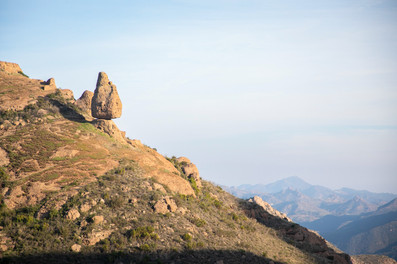


Also along this section, across the canyon, there were some rock climbers as well as a landmark called "Balanced Rock" which is a huge rock that appears to be perfectly balanced on a stone ledge. So along with the vast canyon views, there are plenty of cool things to keep an eye out for.
The next landmark along the trail is "Split Rock", which is literally a giant rock with a split down the middle. It is here that we realized we needed to pick up the pace because we weren't even halfway around and we needed to make it to the peak by sunset. If we weren't power walking the remaining part of the loop, I definitely could have stopped and enjoyed some of the views. The rock formations and the stream that the trail follows for some time were quite pretty. There was also, sadly, some remnants of past fire damage to some of the foliage, but it's encouraging to see that some of the burnt trees were still alive.


As the trail heads south, there will be another fork in the road. The trail to the right goes to the Tri Peaks. The trail that continues straight and to the left is the one you want for Sandstone peak. There is some signage to help if needed. Another quarter of a mile up the trail will be Inspiration Point, a lookout spot and the last landmark before reaching Sandstone Peak. We were racing the sun so we didn't end up stopping here but it seemed like a couple of people had chosen Inspiration Point as their place to watch the sun set.


From here til the peak, the incline is pretty consistent, though not difficult (If you are power walking like we were, you'll feel it). And once you reach the fork in the trail for Sandstone Peak, you'll need to start scrambling up some rocky areas if you want to reach the actual peak. This was probably the most strenuous part of the whole hike.
We were definitely not alone at the peak. There were at least two or three other groups of people there to watch the sunset, but there was room enough for everyone. The ocean wasn't as visible by this point because a marine layer had come in, but we could see a little bit in the distance. The sunset was also covered by some clouds but there were some great moments before it got completely covered.


Once the sun had set and we were losing light, we made sure to get down off the peak before it was too dark. From there you just have to continue along the path to the east and at the last fork before the end, head to the right. This is the first fork you had encountered on the trail at the beginning. The path to the right will bring you back down to the parking lot. We made sure we brought headlamps and flashlights because it didn't take long to lose all the light.

Bottom Line: A very scenic trail in the Santa Monica Mountains with lots to see, and the peak is a great place to watch the sunset.

Comments